Contact Information
Development Services
638 Princess Ave.
Brandon, MB R7A 0P3
Office Phone: 204-729-2110
Fax: 204-728-2406
Email: planning@brandon.ca
Southwest Brandon Wastewater Servicing Project
Southwest Brandon Wastewater Servicing Project - Engagement Process
Recent council and community feedback on the southwest borrowing by-law has identified the need for improved understanding as we move forward with growing our community. To achieve this purpose, the City will have a 4-stage engagement process, including two special council meetings, a public open house, and a second public hearing to provide information on planning and paying for growth.
- Planning For Growth - Special Council Meeting #1
Monday, December 12, 2022 at 5:30 p.m. | City Hall Council Chambers
Session provides background on why, where and how we plan for growth, including discussion on land use and infrastructure planning at city, area, and project scale. View YouTube Video of Special Council Meeting
 Planning for Growth Presentation (2.22 MB)
 Planning For Growth Council Report (2.25 MB)
 - Paying For Growth - Special Council Meeting #2
Tuesday, January 10, 2023 at 5:30 p.m. | City Hall Council Chambers
Session provides background on how we pay for growth including the balance between development charges, utility rates, and property taxes. View YouTube Video of Special Council Meeting
 Paying For Growth Presentation (1.94 MB)
 Paying For Growth Council Report (1.31 MB)
 - Public Open House
Tuesday, January 17, 2023 from 5 - 7 p.m. | City Hall Foyer
The public is invited to review both Planning and Paying for growth topics with stations and boards to engage residents on a topic basis. Planning & Paying For Growth Open House Boards (2.85 MB)
 - Public Hearing
Monday, January 23, 2023 at 5:30 p.m. | City Hall Council Chambers
Second public hearing with consideration of borrowing by-law for 3rd reading by City Council.
![]() Southwest Brandon Wastewater Servicing Project (825 KB)
Southwest Brandon Wastewater Servicing Project (825 KB)
What
The City has determined the southwest area will be a focus for residential and commercial growth. New wastewater infrastructure is required to support continued development.
Why
The existing area wastewater network is nearing capacity; lift station(s) are required to direct the wastewater to the nearest acceptable location and to overcome topographic challenges with the desired service area.
Project Funding
City Administration is proposing a debenture through general borrowing, requesting a borrowing authority of $30 million. Debentures will be issued in series based on cash flow requirements over the various project phases.
Wastewater Servicing Definitions
Lift Station: A pumping station that moves wastewater from a lower elevation to a higher elevation. Also provides ability to direct wastewater from one point in the collection system to another.
Wastewater Trunk Sewer: Large diameter sewer pipe that allows for flow by gravity. Residential and commercial developments connect to the trunk sewer, which directs the wastewater to the lift station.
Forcemain: A pressurized sewer pipe that leaves the lift station and discharges wastewater into the downstream collection system.
Southwest Brandon Service Area
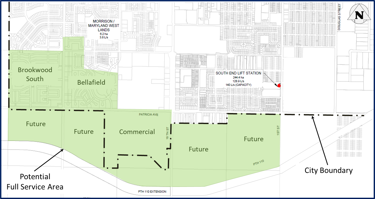
- City endeavors to provide wastewater service to Brookwood South, Bellafield, and Commercial property south of Patricia Ave.
- City is looking to capitalize on opportunity to setup for future growth areas.
- Servicing will be completed through a phased approach.
Wastewater Servicing - Concept Overview
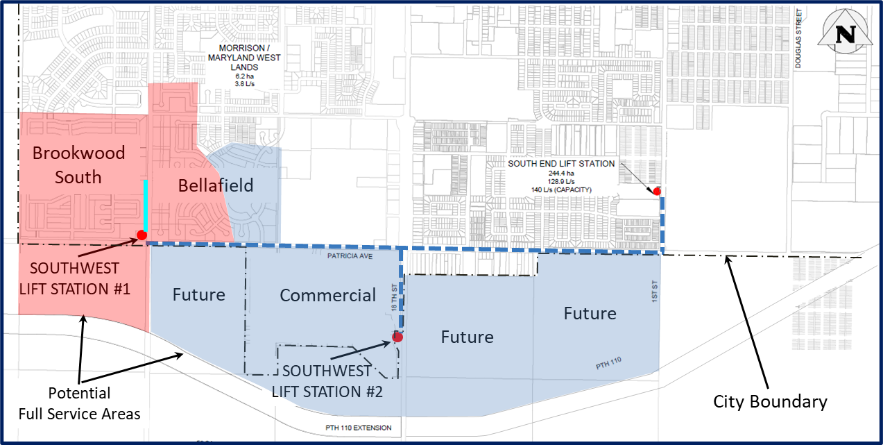
- Multi-phased wastewater servicing project to facilitate growth in southwest Brandon.
- Principally two phases with multiple construction contracts within each.
- Design is currently underway with City targeting first construction contract to be tendered in Fall 2022.
Wastewater Servicing - 34th Street Phase
34th Street Phase includes:
- Construction of lift station near the intersection of 34th Street and Patricia Avenue
- Wastewater trunk sewer extending north to service adjacent developments
- Forcemain from the lift station to connection at existing forcemain on 1st Street, downstream of existing South End Lift Station
- South End Lift Station upgrades
- Fiber optic communications installation
Wastewater Servicing – 18th Street Phase
18th Street Phase includes
- Construction of lift station on 18th Street (PTH 10) south of Patricia Avenue
- Wastewater sewer extending north and west to service adjacent developments
- Forcemain from the lift station to connection at existing forcemain on 1st Street, downstream of existing South End Lift Station
- Fiber optic communications installation
Southeast Brandon Drainage Improvements Project
Last Update: February 5, 2025
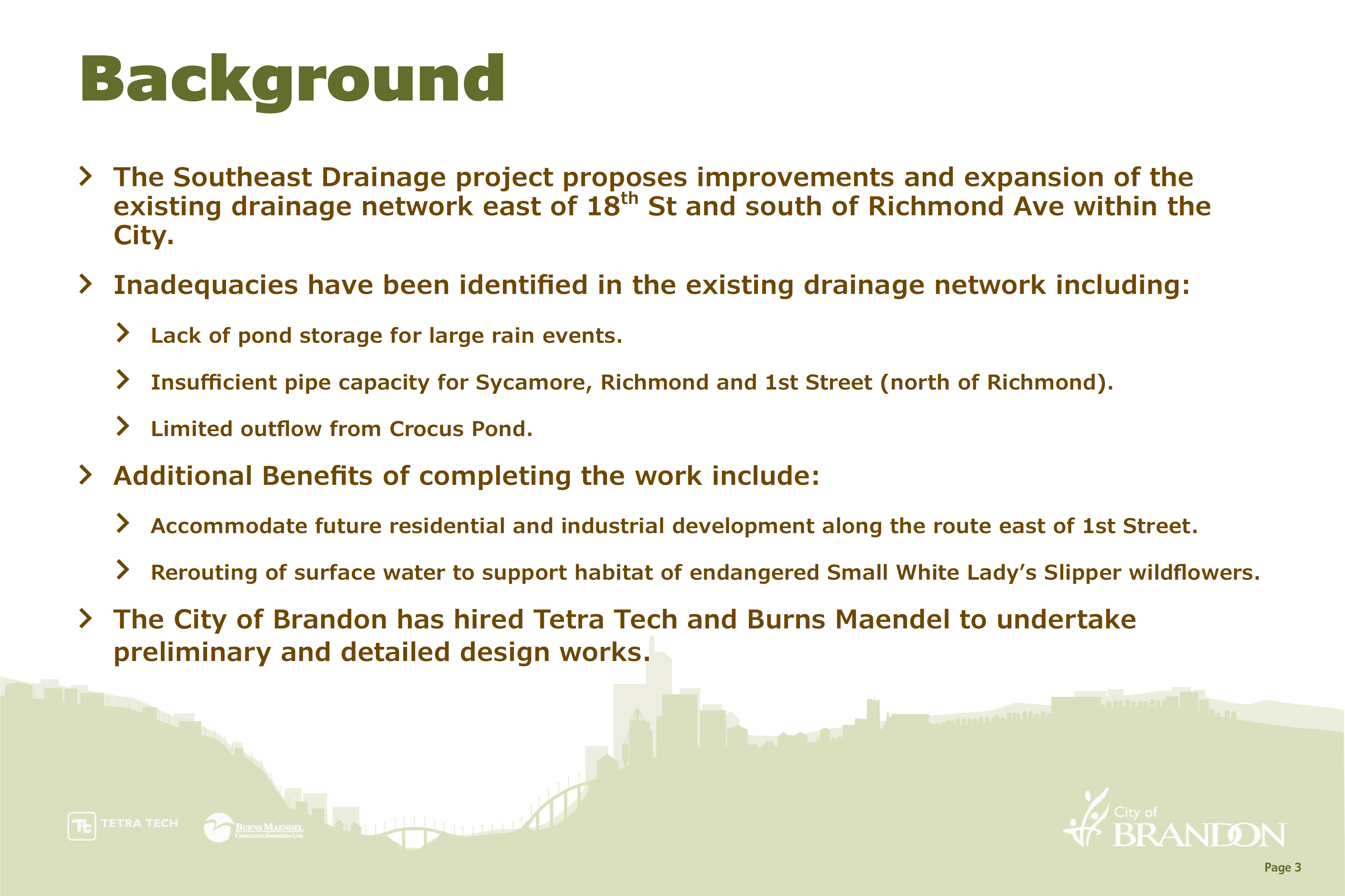
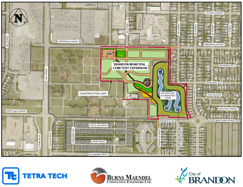
In 2025, construction will begin on the Brandon Municipal Cemetery Naturalized Stormwater Pond and Drainage Project. This project is part of the Southeast Brandon Drainage Improvement Project and a strategic action in the City of Brandon’s Climate Action Plan. This new stormwater retention pond, designed in accordance with the City of Brandon Naturalized Stormwater Pond Guidelines, will be constructed on the east side of the Brandon Municipal Cemetery grounds and will deliver many benefits including improved stormwater management. The pond will become a community amenity, providing habitat and opportunities for social connection, and will also enable the expansion of the cemetery and the future achievement of the Cemetery Master Plan.
City of Brandon - Climate Action Plan
City of Brandon - Naturalized Stormwater Retention Basin's
City of Brandon - Cemetery Expansion Master Plan
![]() Southeast Drainage Improvements Project Open House 2022 (5.3 MB)
Southeast Drainage Improvements Project Open House 2022 (5.3 MB)
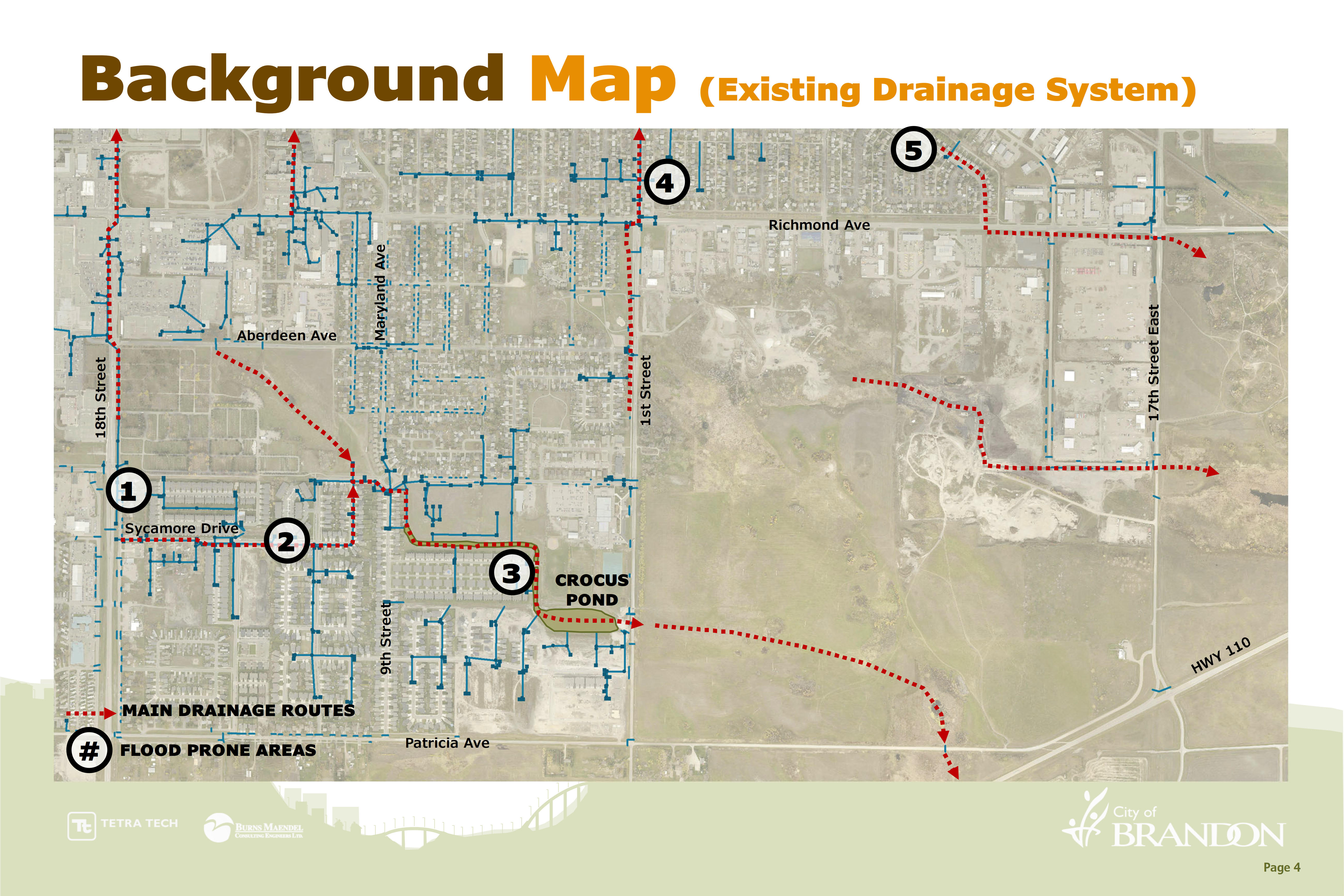
- Map demonstrates general drainage direction and routing
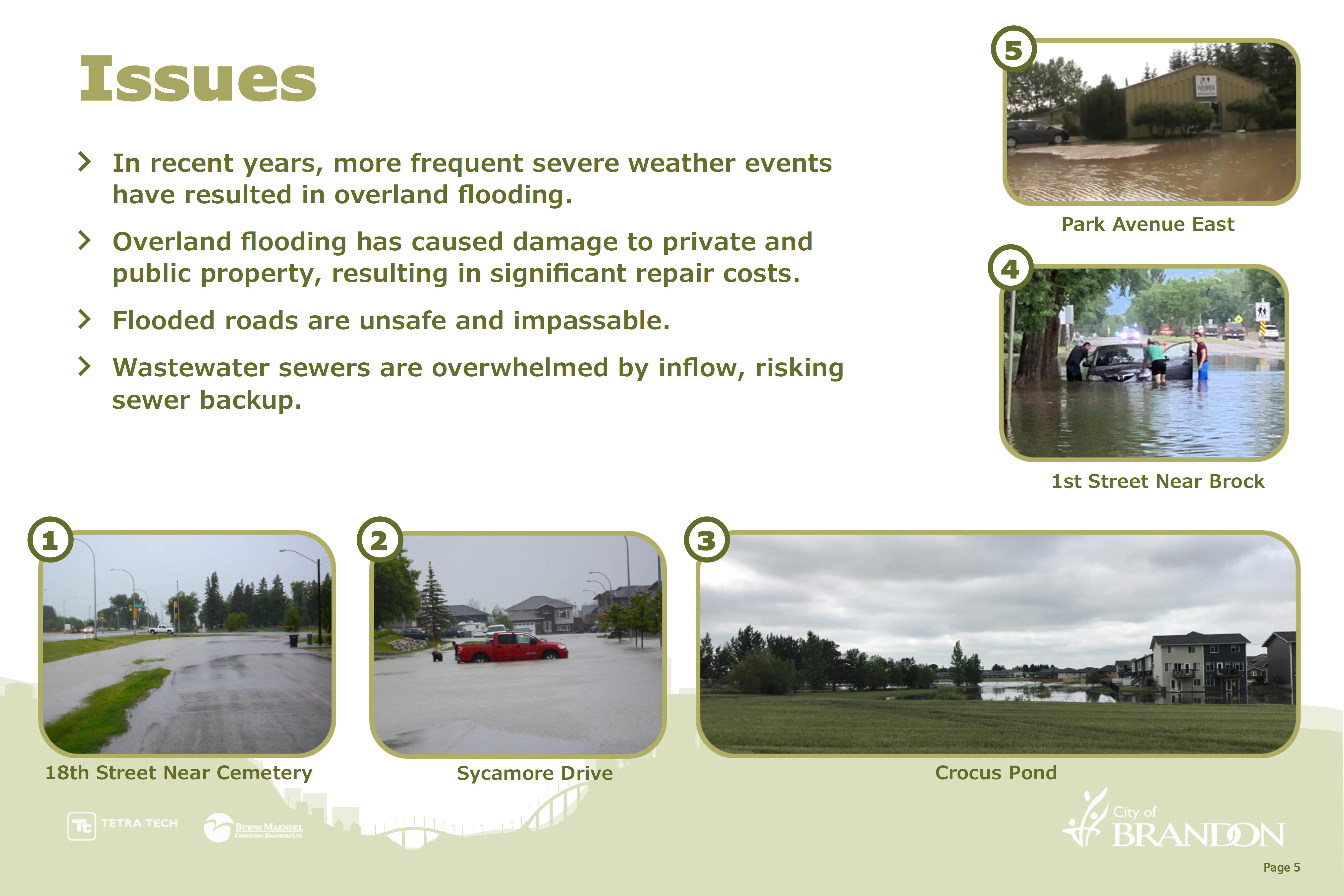
- Flood Prone Areas are denoted with a number corresponding to a photo on the next board
- There have been numerous reports of property damage within the existing Southeast Drainage Basin and surrounding area
- Wastewater sewers experience inflow through manhole covers during overland flooding events, risking sewer backup. This additional flow in the wastewater sewer means unnecessary extra cost to the City for treating runoff (rain) and also results in load shedding (diversion of wastewater flows to the river).
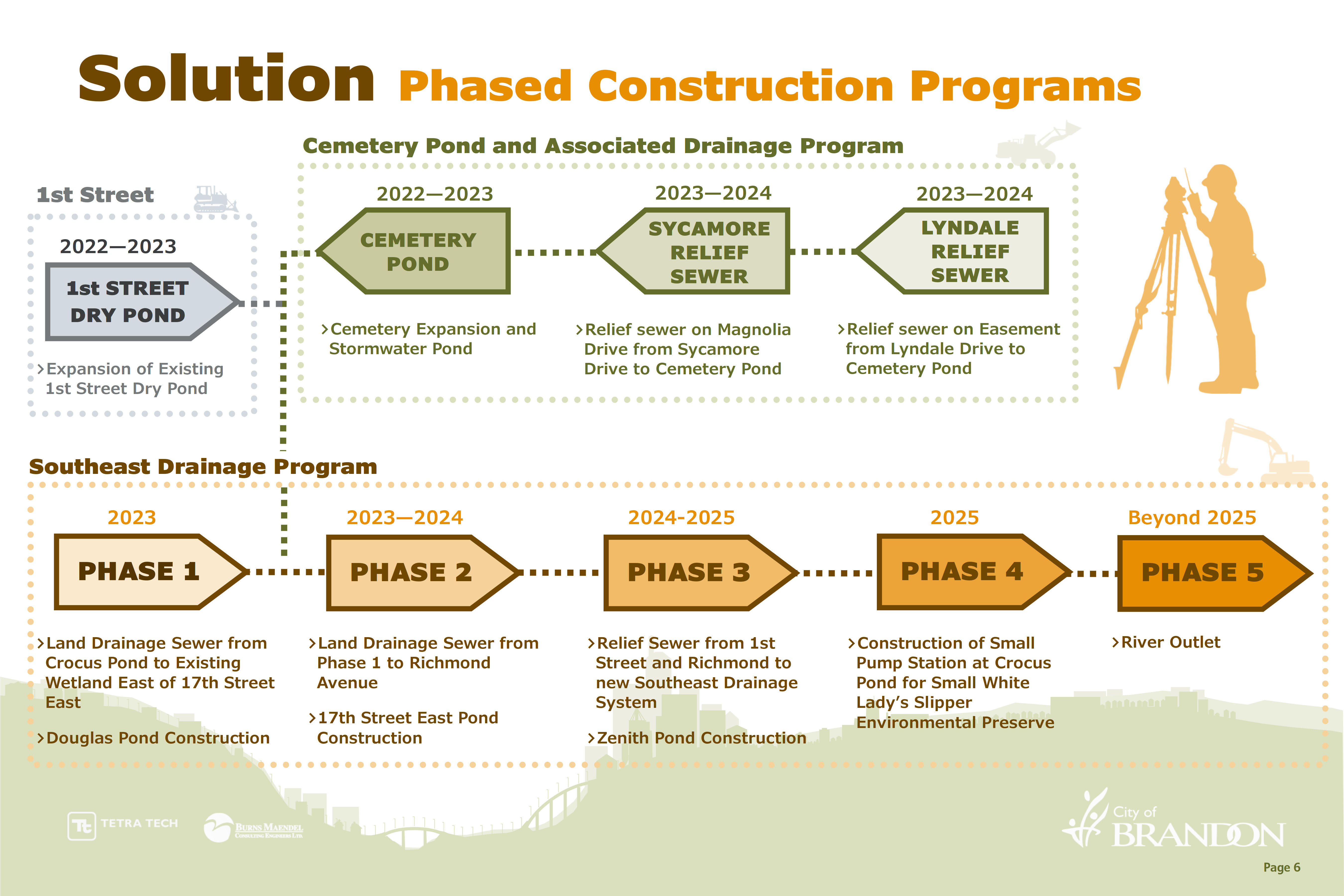
- The City will be completing the design and construction of new stormwater infrastructure over multiple years.
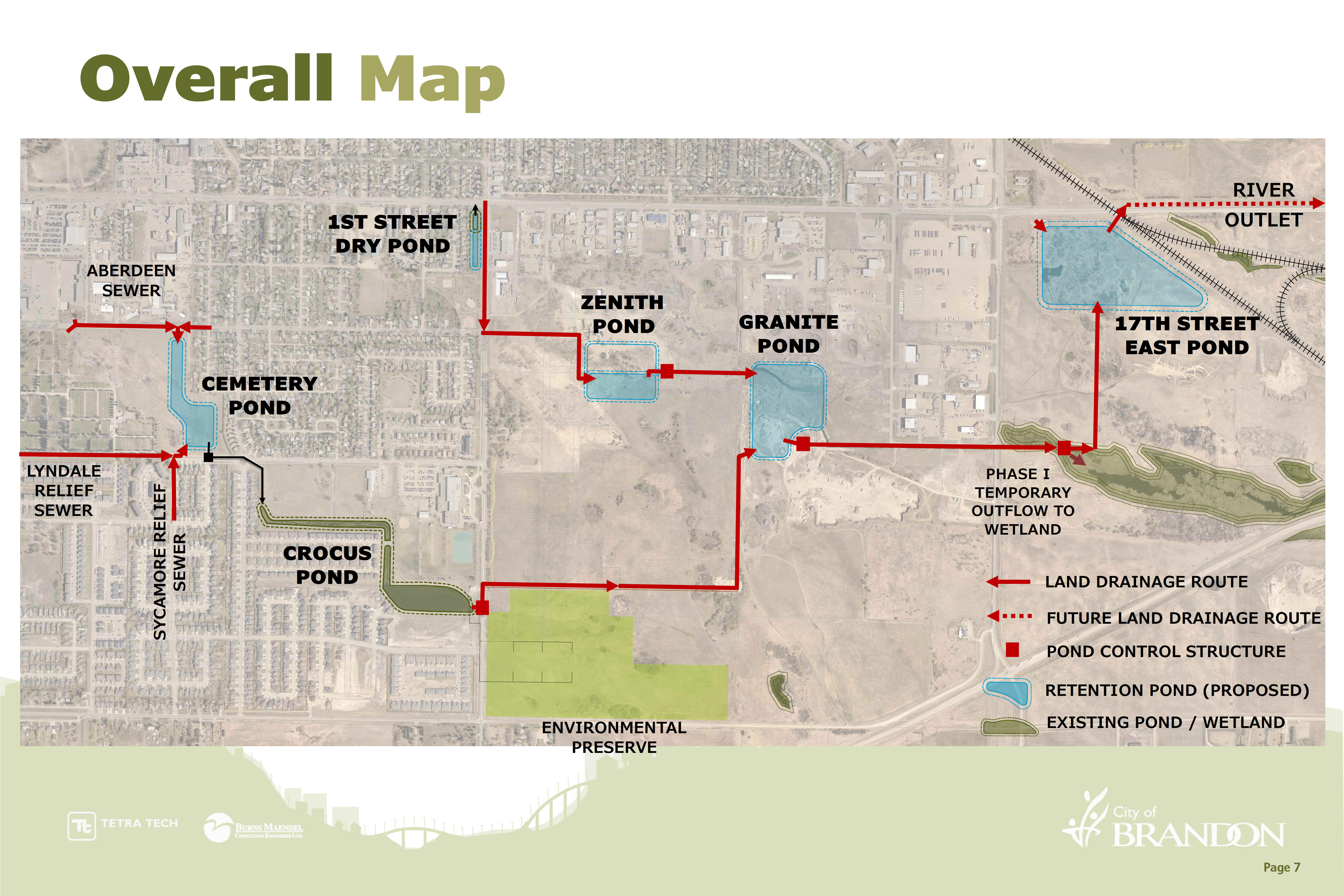
- The Phased Construction Program will see new infrastructure within the existing Southeast Drainage network and within the Southeast Area and the East Brandon Industrial Area
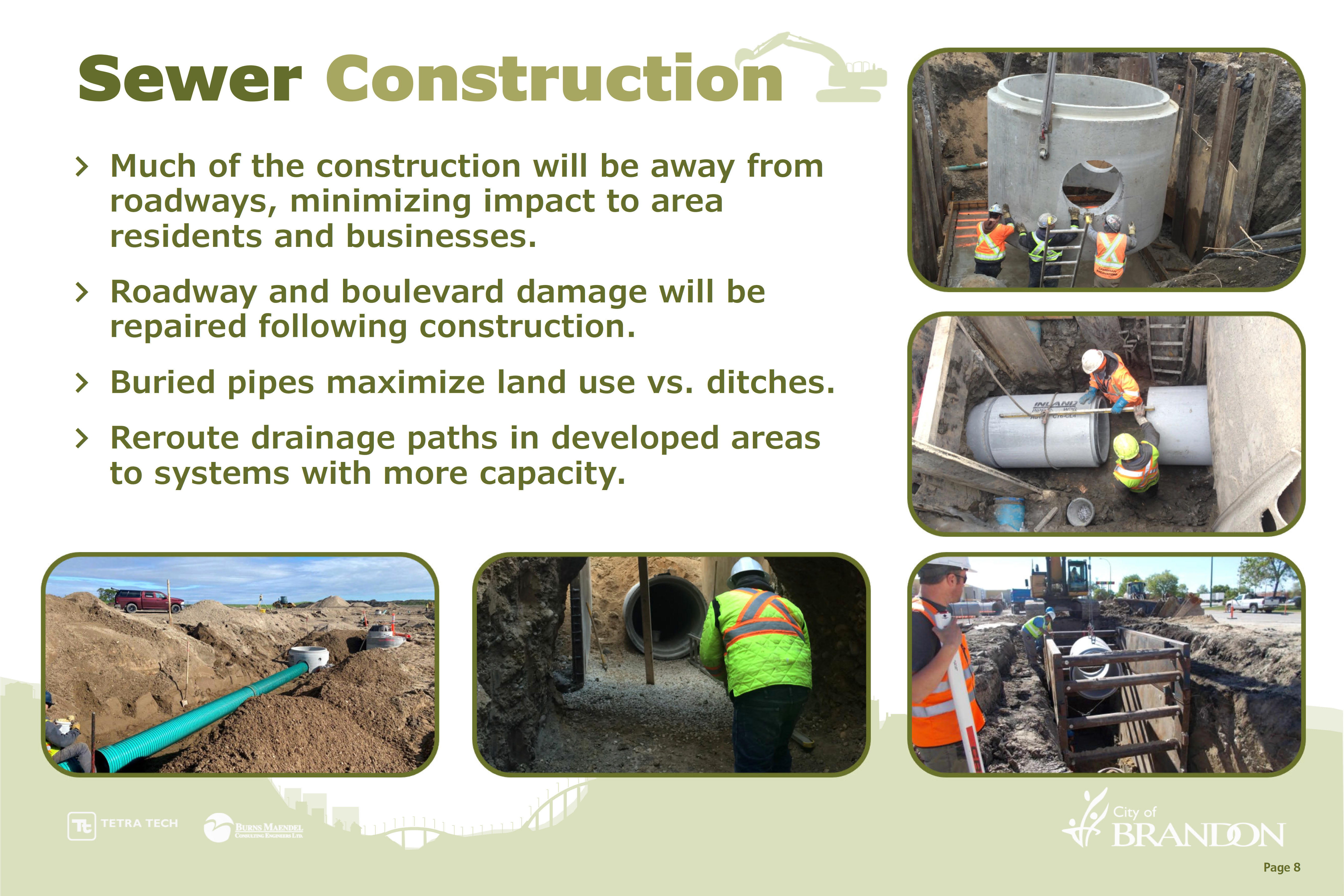
- A majority of the proposed construction will take place away from roadways.
- The work associated with the Cemetery Area Drainage and a good portion of the Southeast Drainage will include construction of new land drainage (stormwater) sewers.
- Sewers, swales, drains/channels provide conveyance and allow for the movement of the stormwater
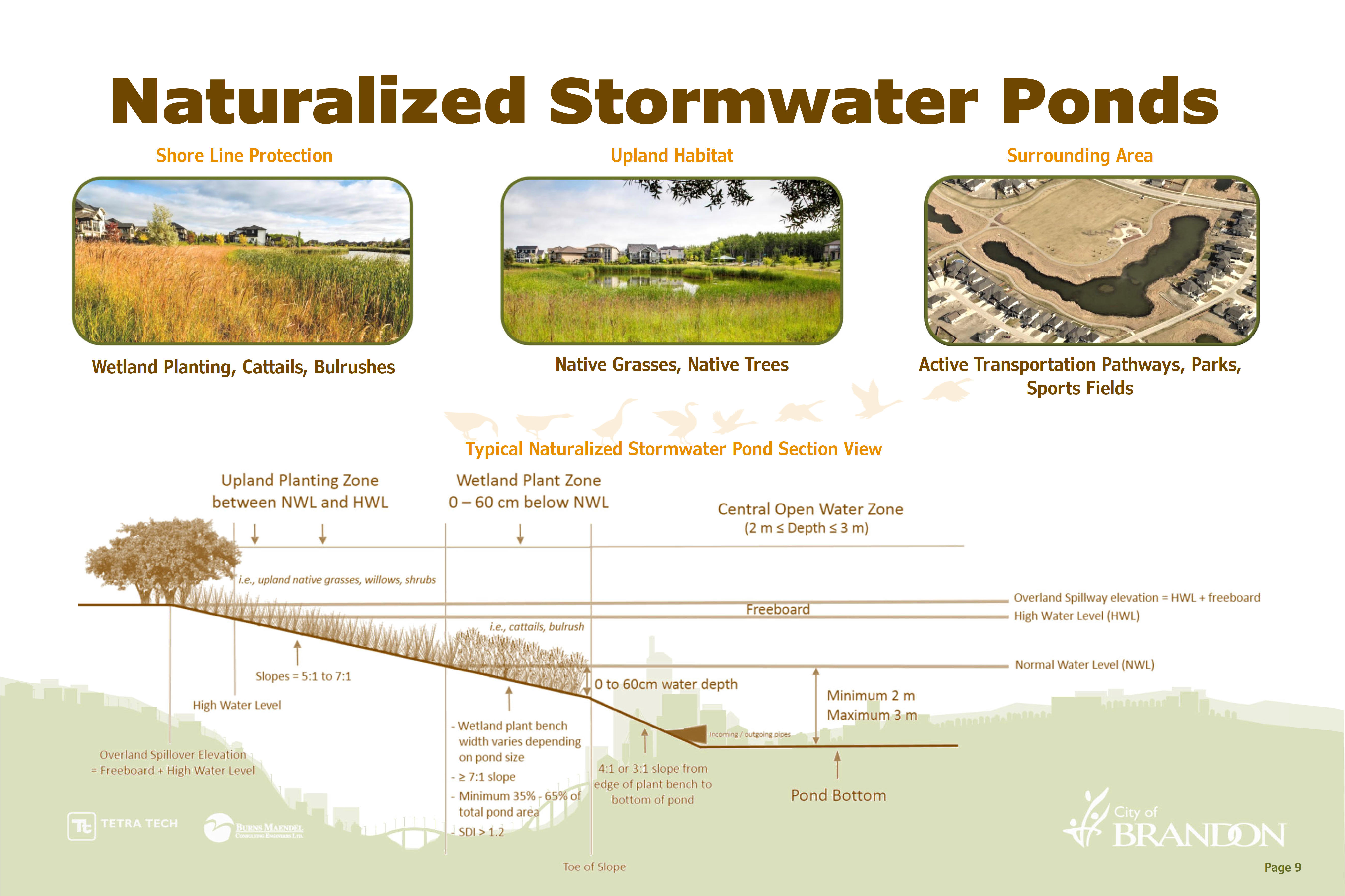
- A total of 4 stormwater retention ponds are currently proposed for construction as part of the Southeast Brandon Drainage Improvements Project.
- These ponds are proposed to be naturalized stormwater ponds (NSP). NSP’s typically have 3 zones and are constructed with _____
- Check out the City of Brandon’s Naturalized Stormwater Pond Guidelines
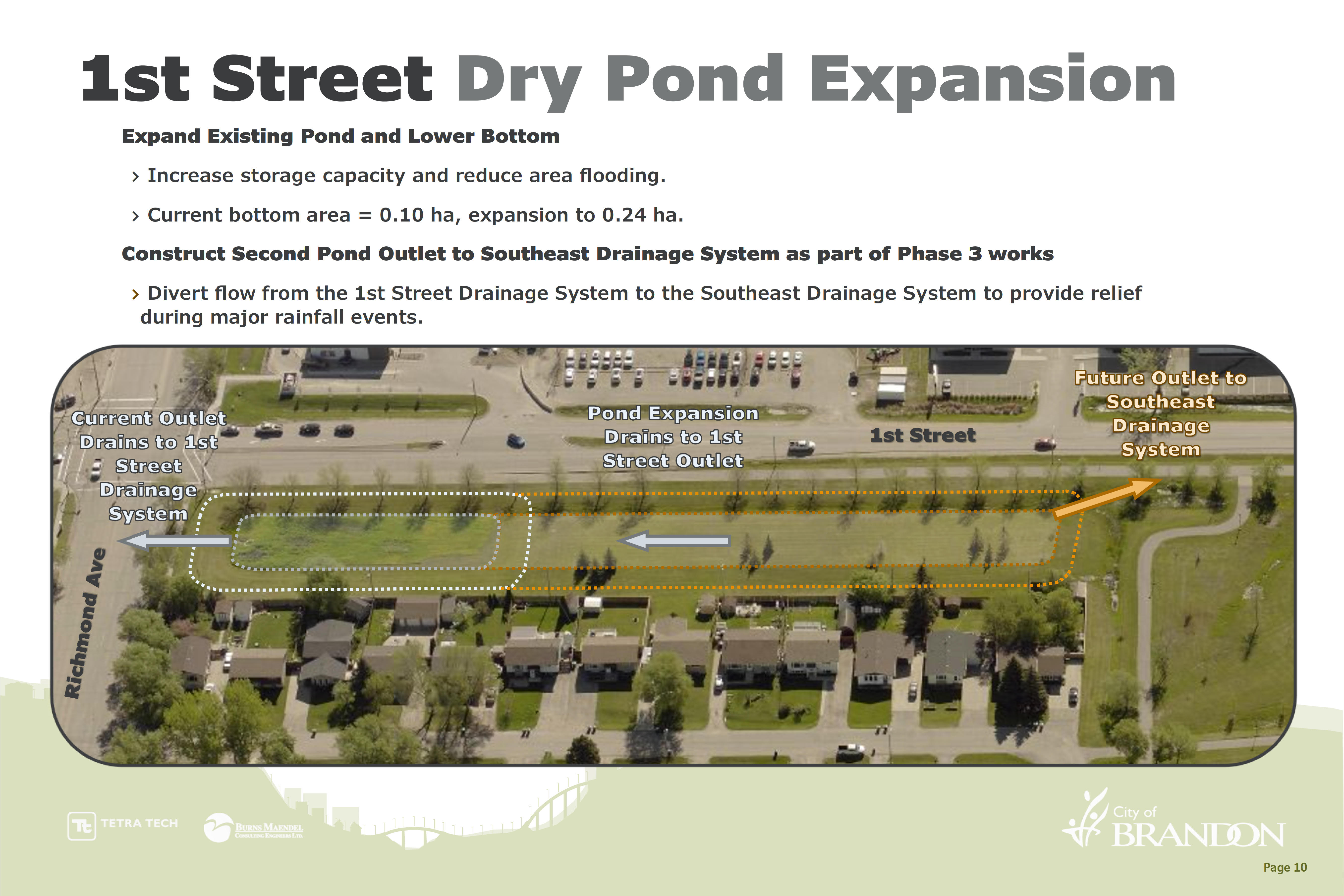
- While Phases 1 and 2 of the Southeast Drainage are being designed and constructed, the City will deepen and expand the existing dry pond at 1st Street and Richmond Avenue.
- This will aid in reducing flooding in the local area near 1st St. and Richmond Ave.
- As part of Phase 3 works an additional outlet will be added to the Southeast corner of the dry pond, allowing it to drain to the new southerly drainage system, offloading the drainage from the north to the south.
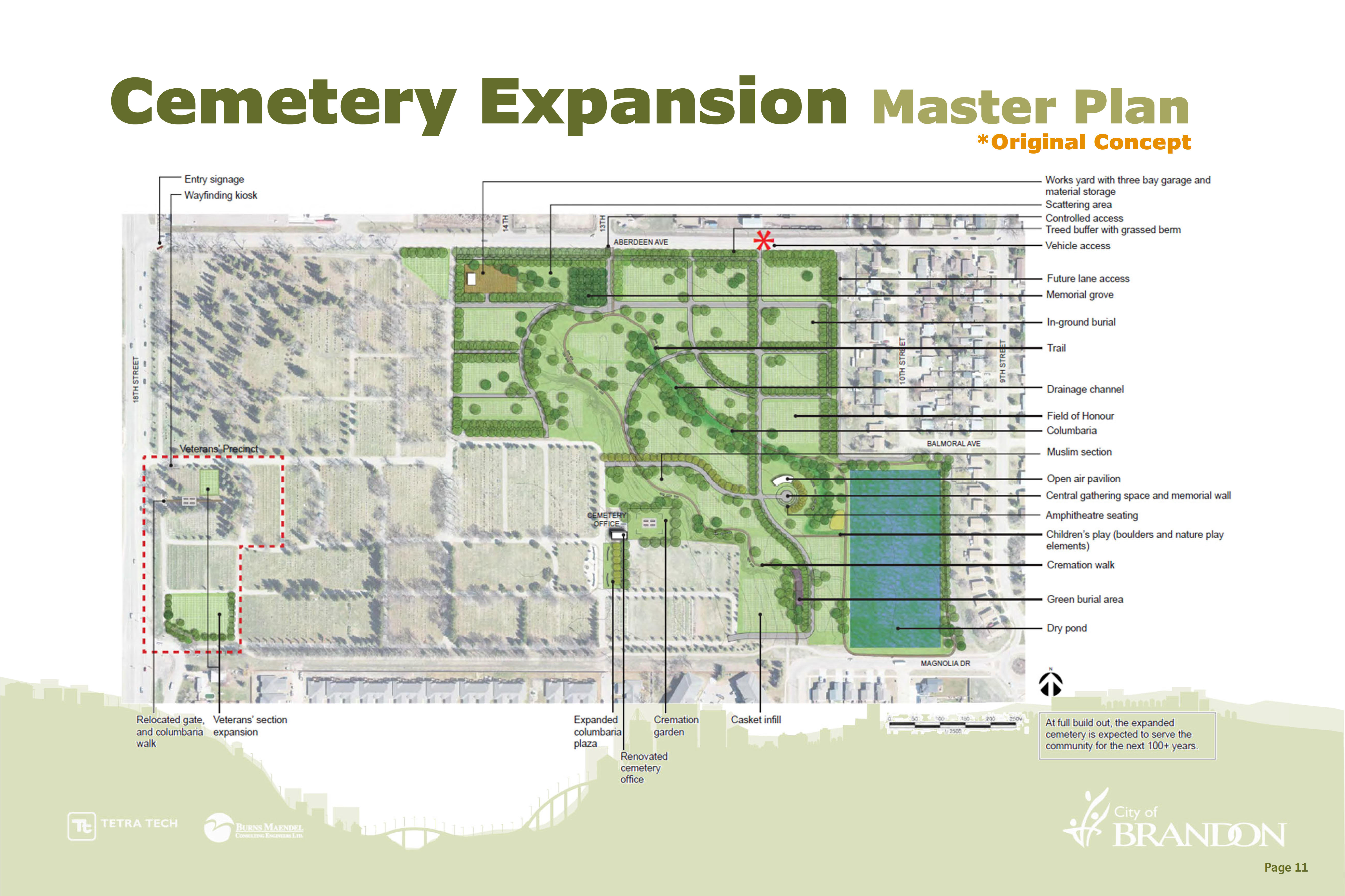
- This conceptual drawing is taken from the 2015 Cemetery Expansion Master Plan.
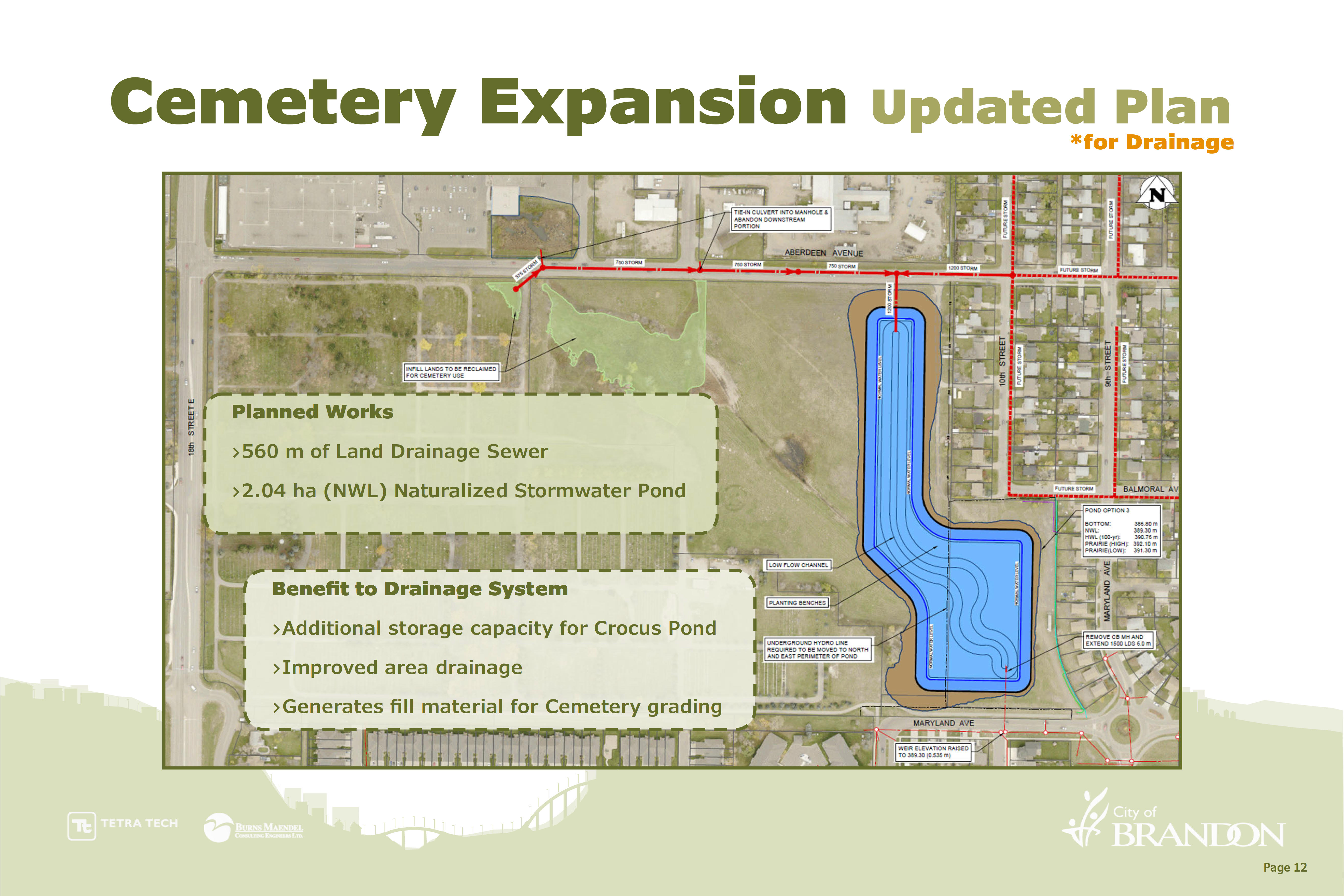
- The first step in the expansion is the completion of the drainage project, the stormwater pond.
- The pond was previously proposed as a dry pond due to numerous constraints that have since been removed. Additionally, Engineering staff stressed the need for maximizing stormwater storage for the Southeast area.
- Cemetery pond has increased in size to provide additional storage
- Cemetery pond is now proposed as a naturalized stormwater pond
- Excavated material from the pond will be used as fill to aid with grading the cemetery expansion area
- Parks staff is working with Engineering and their consultants to reconceptualize cemetery expansion area.
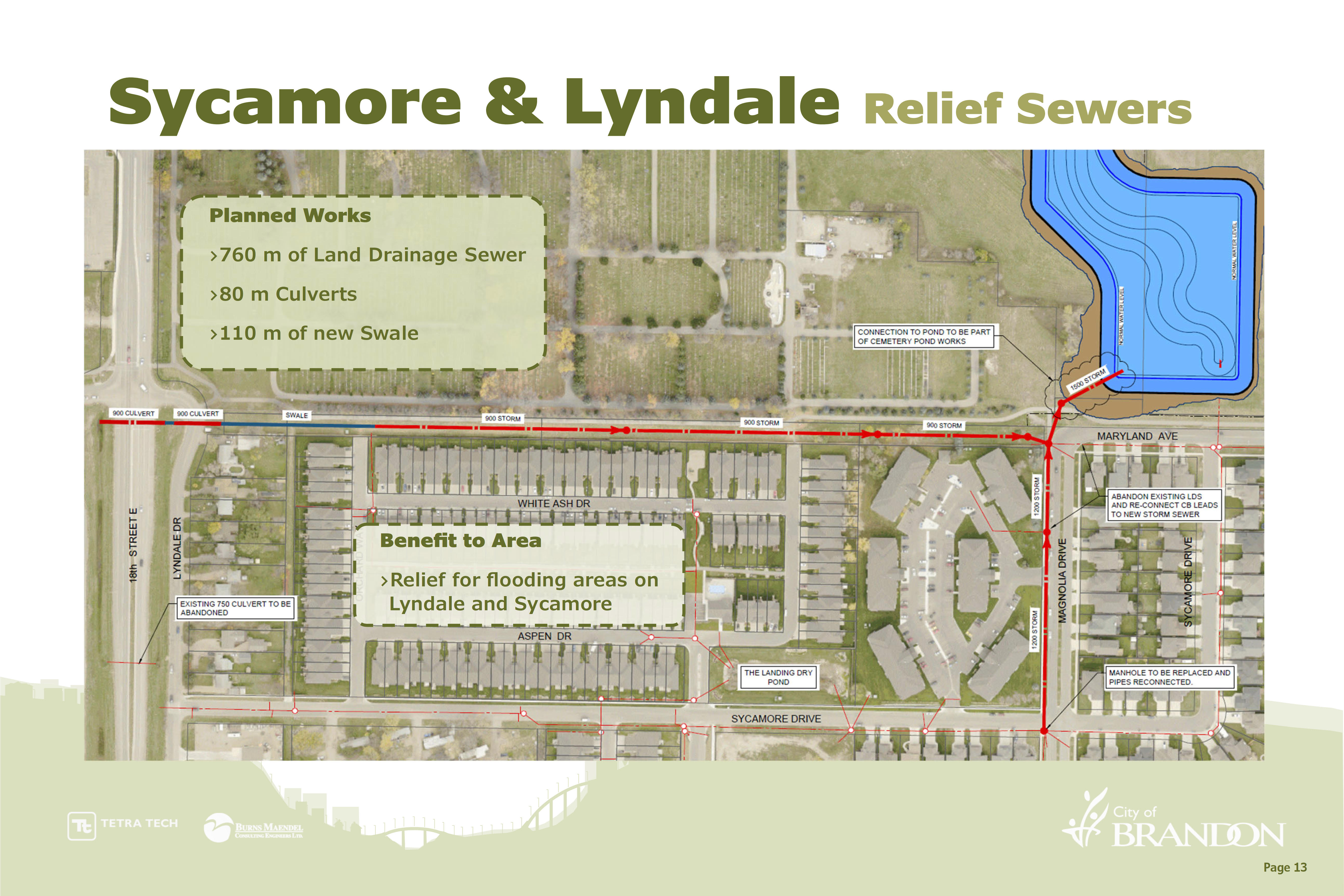
- Current concept to provide relief to areas prone to flooding along Sycamore Drive and Lyndale Drive.
- A combination of culverts, swale and land drainage sewer is proposed long the south side of the existing cemetery. The existing culvert crossing 18th St. is proposed to be abandoned allowing water to store on the west side of 18th St. while also being conveyed to the retention pond in the Cemetery.
- A new land drainage sewer along Magnolia Dr. with provide more capacity for conveyance to the retention pond in the cemetery, effectively eliminating a significant amount of the ponding seen on Sycamore Dr.
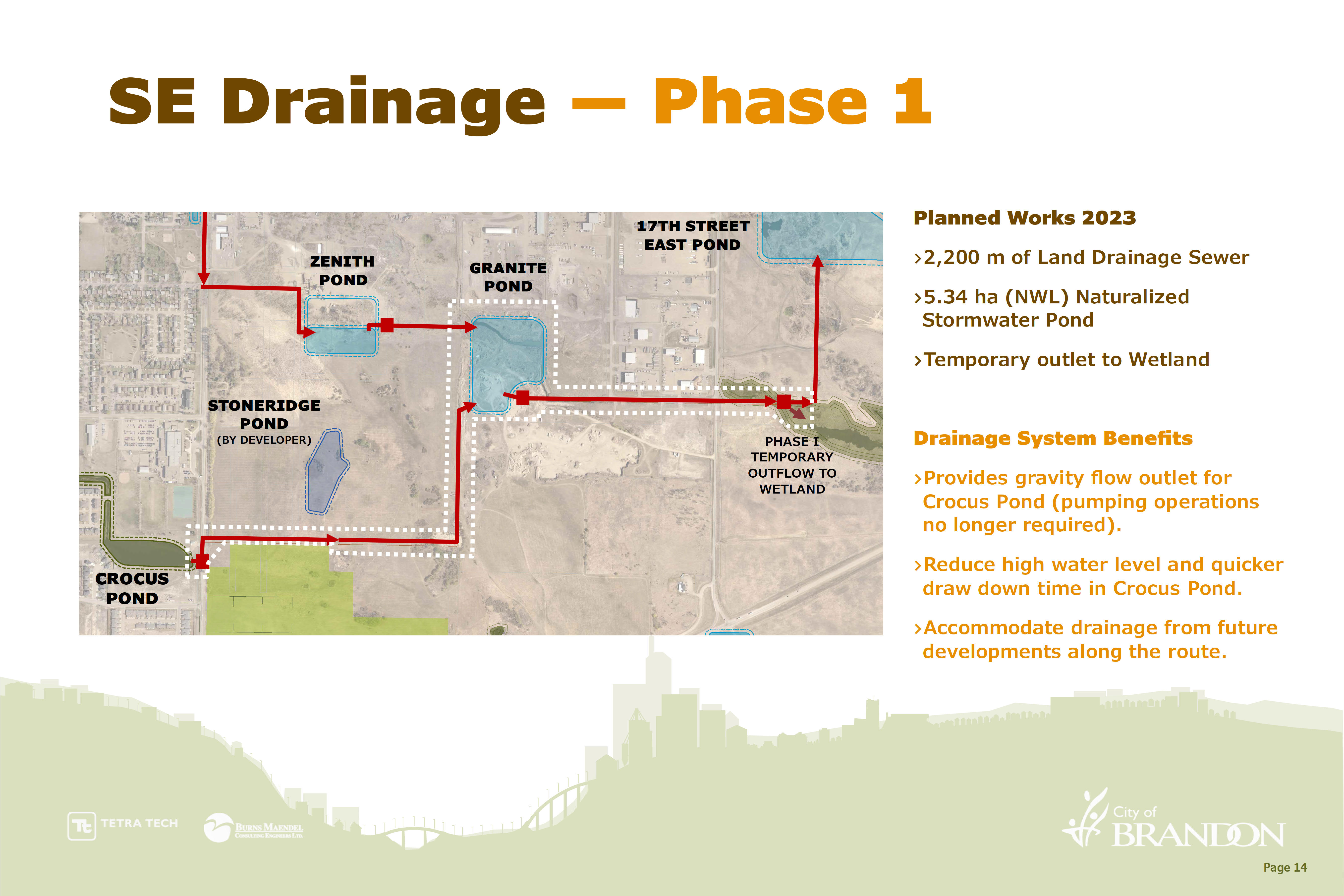
- Includes construction of new naturalized stormwater pond, land drainage sewers, and the outlet for the existing Crocus Pond.
- This phase is proposed to temporarily discharge to the existing wetland on the east side of 17th St. East.
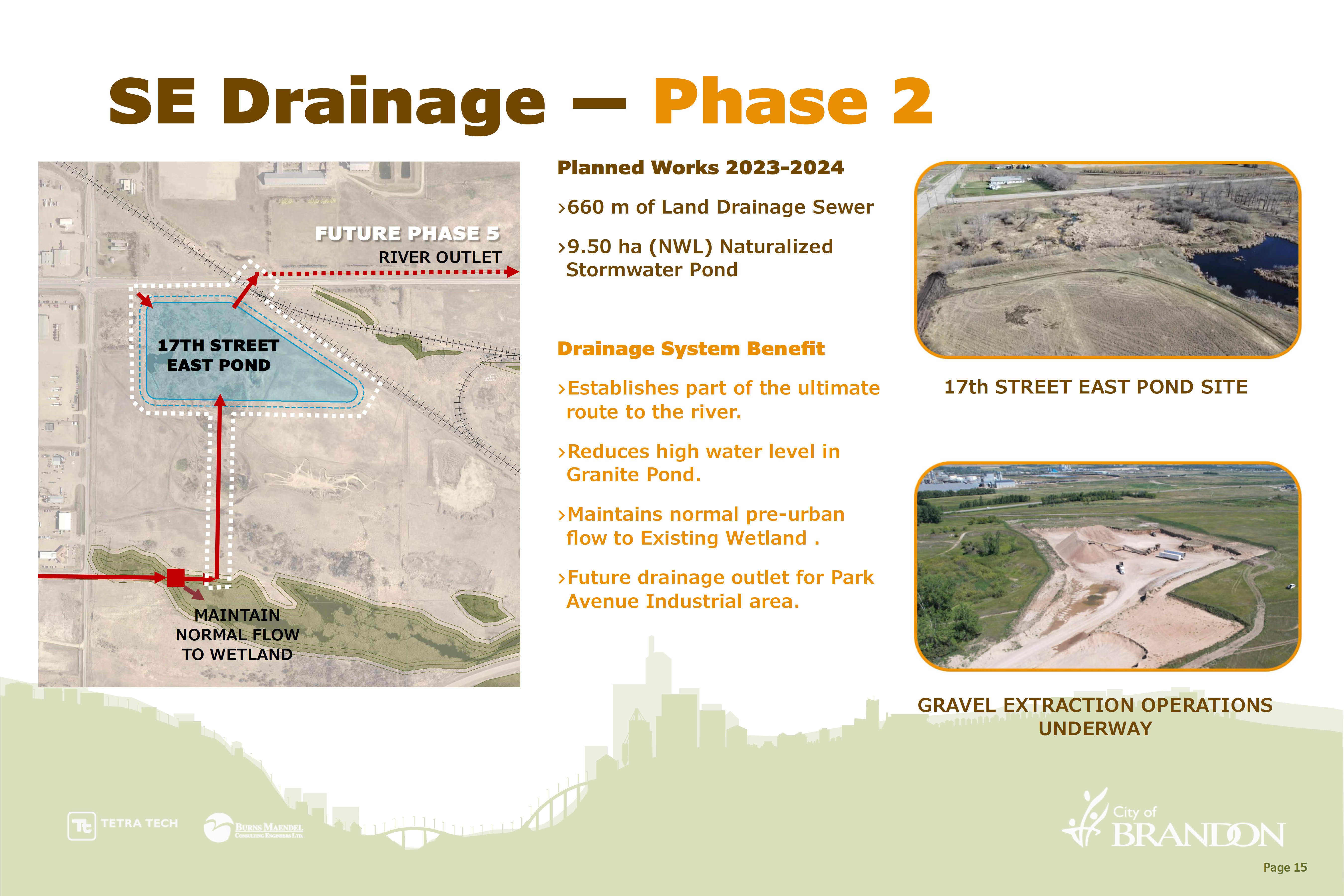
- Includes construction of very large, naturalized stormwater pond.
- Phase 2 will see construction of a control structure to maintain flows to existing wetland while conveying flows to stormwater pond.
- Beneficial opportunity arose for the excavation of the pond area to commence early. This work is taking place at the cost of the contractor excavating the material.
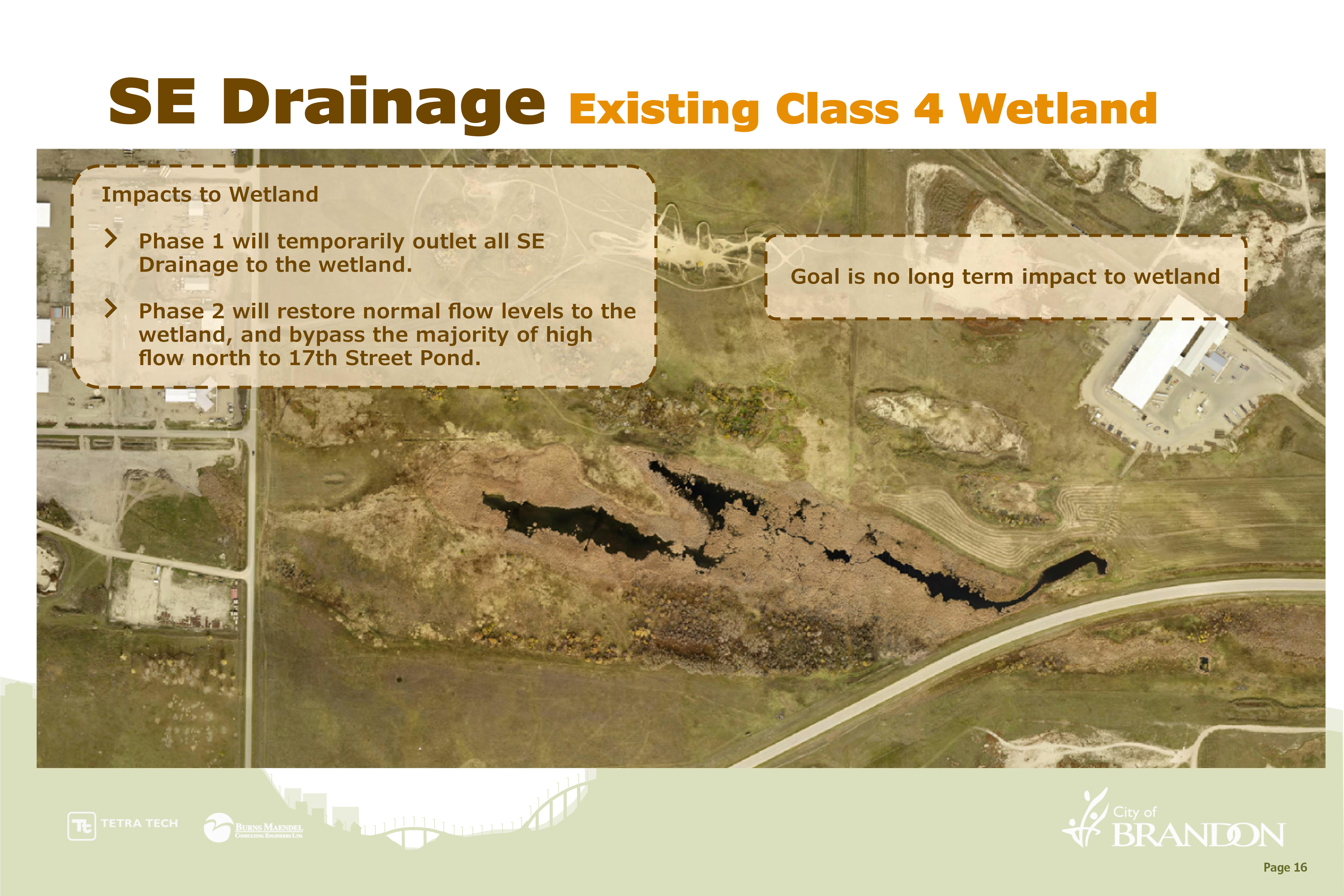
- Phase 1 &2 will be constructed in the vicinity of an existing wetland. For the success of this project the City will require temporary discharge to the wetland, however goal is no long term impact to the wetland. City will be working with Provincial regulators to ensure construction and long term plan is acceptable.
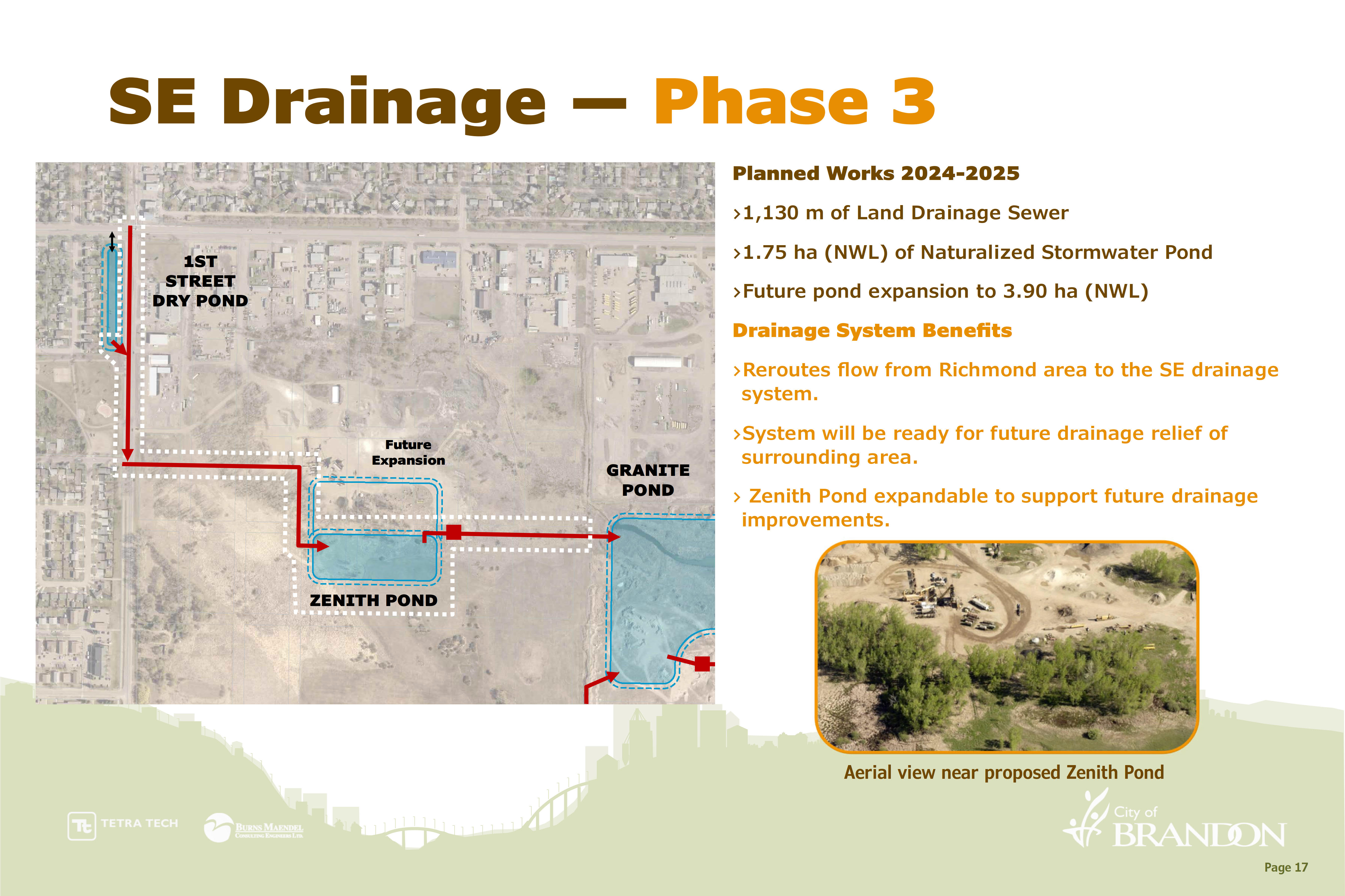
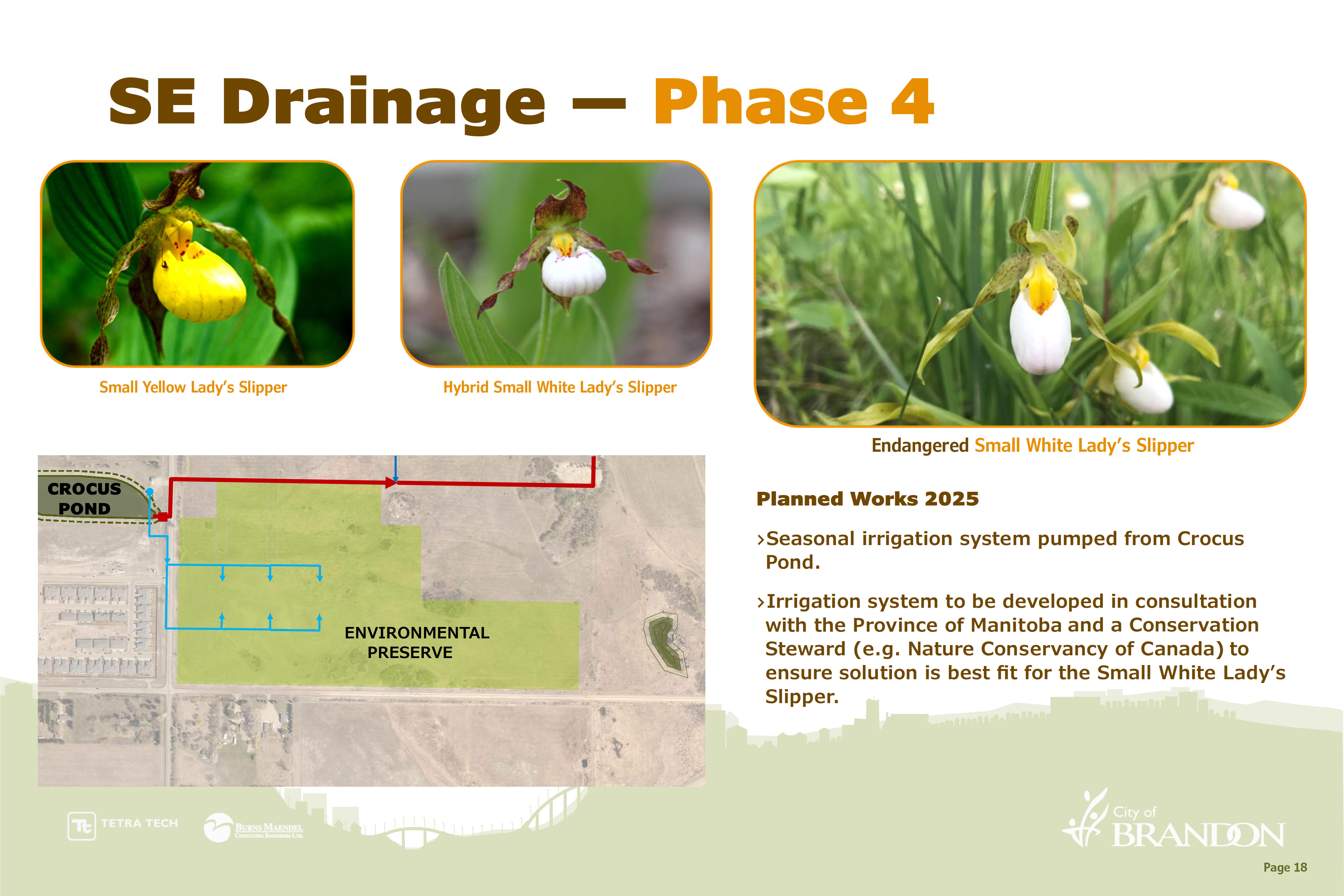
- Includes construction of new naturalized stormwater pond and land drainage sewers.
- This phase will effectively redirect flows currently going north, to the new southeast drainage system.
- The proposed Zenith pond would be expanded in the future to support development local to this area.
- Conceptual design of irrigation system to support the proposed environmental preserve as currently required by the Province of Manitoba.
- Any system or support to the environmental preserve will be developed in consultation with the Province of Manitoba and a Conservation Steward such as Nature Conservancy of Canada.
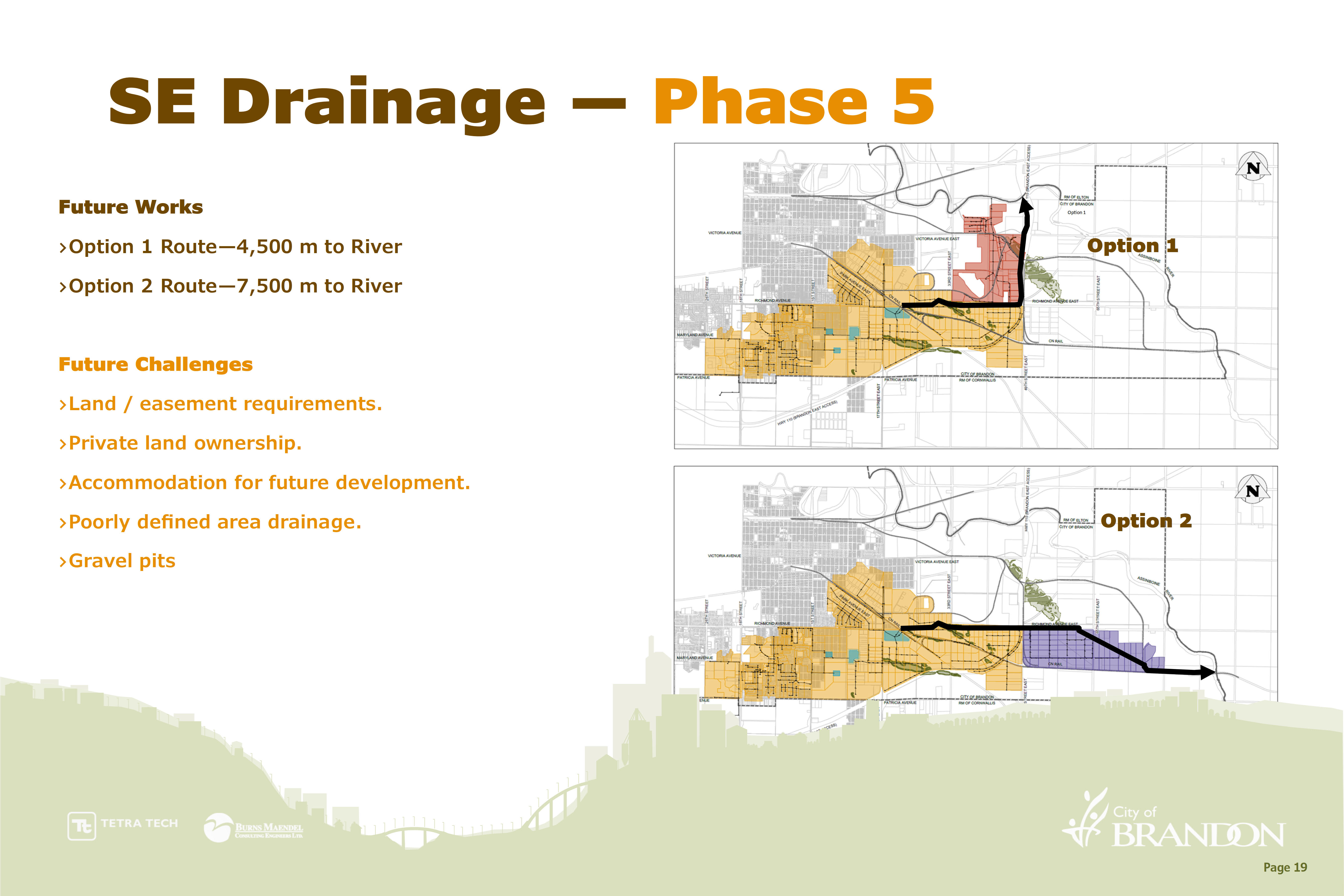
- Phase 5 is the ultimate constructed drainage route to the Assiniboine River.
- There are predominantly two options given consideration at this time, conveyance of drainage flow to the north or east.
- There are several future challenges associated with Phase 5, including those listed on the image above.
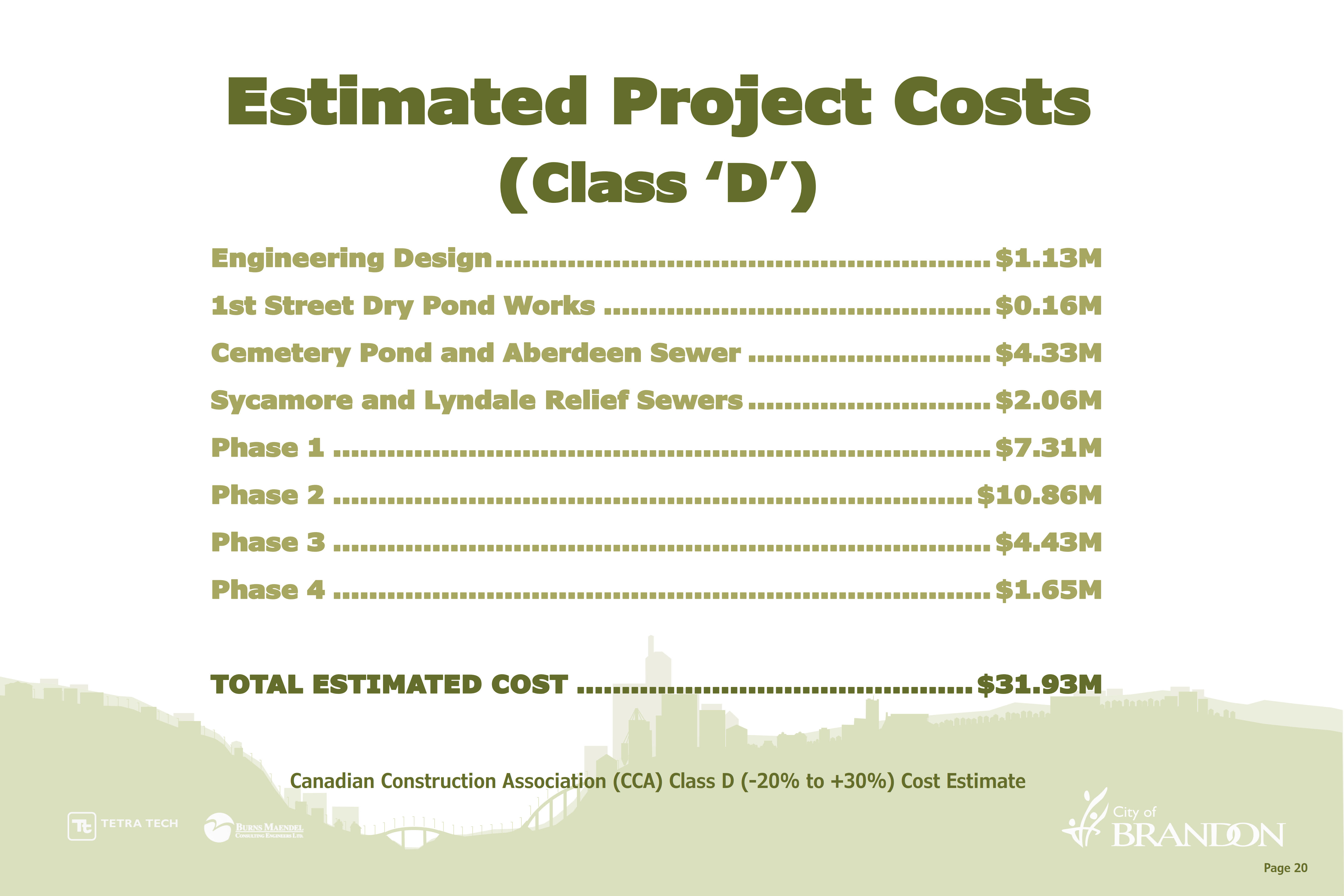
- At this time, the total project estimated cost is $31.93 million.
- The City has received approval from Municipal Board and City Council to borrow fund up to $30.14 million. The remainder of the funds are coming from existing reserves.
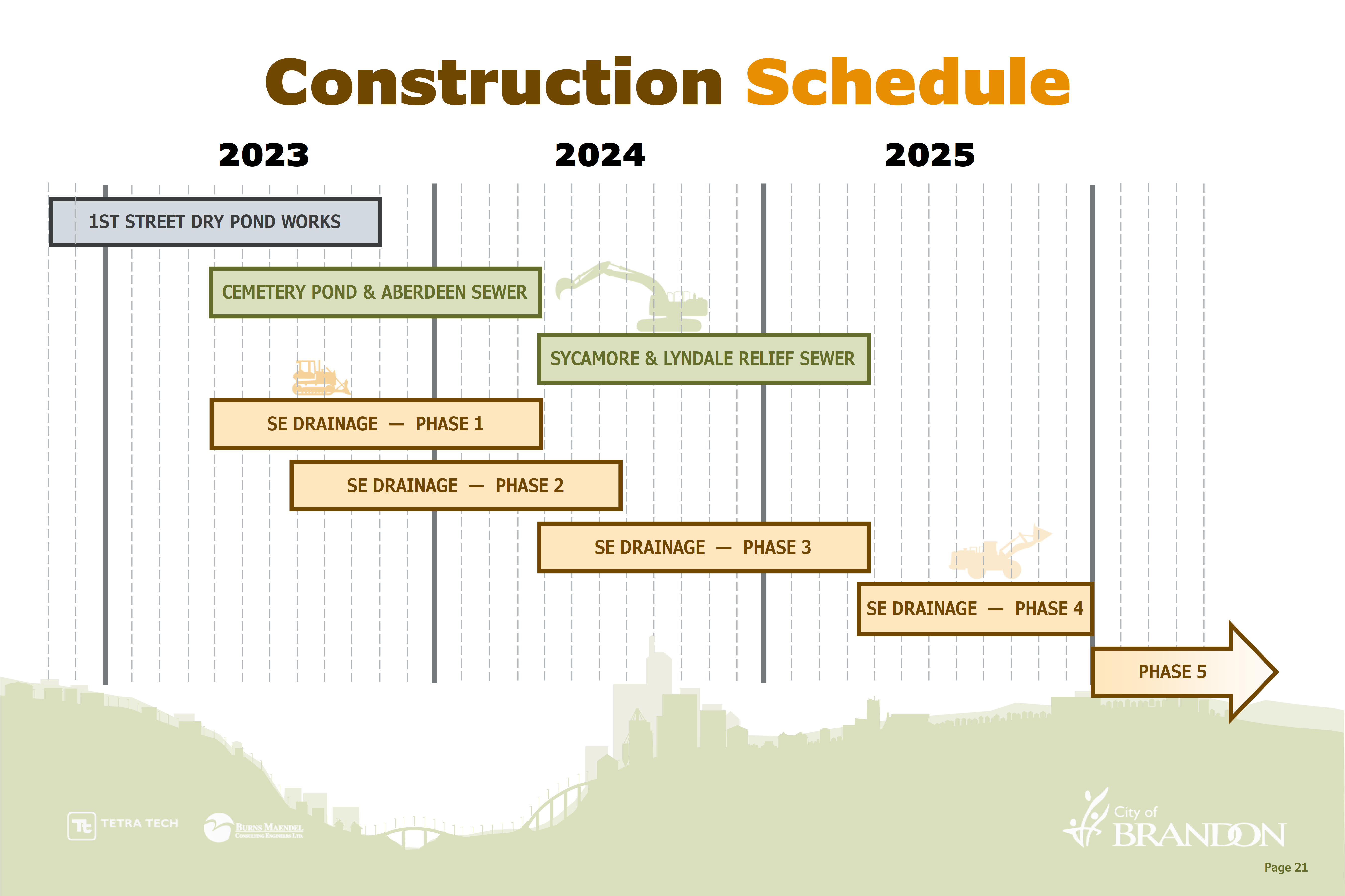
- Construction is phased over multiple years.
- As construction contracts are awarded and construction nears, required residents and businesses will be notified of upcoming construction activities and impacts.
Previous Updates
April 2022
New Provincial Building, Plumbing, Energy, and Fire Codes Coming Into Effect January 2024
City of Brandon Development Services section is advising all developers, property owners, and residents of Brandon that the Province of Manitoba will be adopting and enforcing the 2020 editions of the national model construction codes effective January 1, 2024. Permits issued after January 1, 2024 will be required to adhere to the new standards.
The updated construction codes include the Building, Plumbing, Energy, and Fire Code regulations. By adopting and enforcing the new 2020 code, the Province of Manitoba honours its commitments to the Canadian Free Trade Agreement by harmonizing the adoption of national codes.
Plans are underway by the City of Brandon to provide guidance on the upcoming changes. We encourage all interested parties to subscribe to the Development Services Email Updates for more information as it becomes available.
For further information about changes to the new provincial codes, please contact Development Services at 204-729-2110 or planning@brandon.ca.
For more information about the provincial or national codes, please visit gov.mb.ca or nrc.canada.ca.
2020 Code Changes Training Seminar
November 27-28, 2023
Clarion Hotel, Brandon
The update will cover code changes from 2010 through 2020 in the Manitoba Building, Plumbing and Energy Codes at a high level.
Red River Polytechnic Instructors - Tammy Harper and Trevor Dackow.
Day 1 - Building Codes
Schedule
7:30-8:15 am - Registration
8:15-8:30 am - Opening Remarks
8:30-4:30 pm - Seminar
Day 2 - Plumbing and Energy Codes
Schedule
8:00-8:55 am - Registration
9:00-4:00 pm - Seminar
FEES & HOW TO REGISTER:
Click here to register.
Fees include refreshments and lunch.
GST is not applicable.
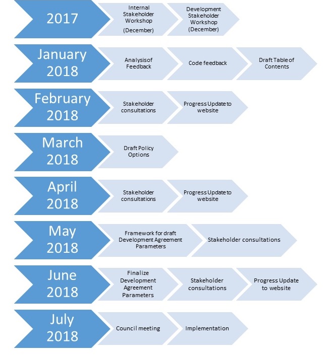
Development Agreement Parameters
What is a Development Agreement?
A Development Agreement is a legally binding agreement, registered on all affected land, between the developer/property owner and the municipality. A Development Agreement covers matters relating to the following:
- Responsibilities and expectations of both the municipality and the developer
- Financial obligations required to facilitate the development
- Municipal improvements such as water, wastewater, drainage and transportation infrastructure
- Land acquisition and dedication
- Public amenities
- Compliance and enforcement
Why is a Development Agreement Required?
Development Agreements are required to clearly identify the responsibilities of the municipality and the developer to ensure that the proposed development is safe, efficient, compatible with surrounding land uses, a benefit to the community and generally consistent with the intent of the municipality’s Development Plan.
When is a Development Agreement Required?
When a developer / property owner proposes new or infill development, the municipality has the authority to require a Development Agreement as a condition of the following land use applications:
- Re-zoning
- Subdivision
- Variance
- Conditional use
What are Development Agreement Parameters?
Development Agreement Parameters (DAP) will be a City Council approved policy, that:
- Communicates the general development policy of the municipality on behalf of all associated City departments
- Ensures that all parties involved pay their equitable share of associated costs as a result of development
- Ensures agreement obligations are transparent, consistent and fair
- Decreases time and effort spent on agreement negotiations
- Will streamline the land use application approval process and support standard construction specifications.
Why do we need Development Agreement Parameters?
Currently, the City of Brandon and the development industry negotiate Development Agreement terms on a case-by-case basis in accordance with City by-laws, policies and standard construction specifications and practice.
In order to promote and support a fair, consistent and transparent process to the development industry as a whole, the Development Services Division will work with the community to create City of Brandon “Development Agreement Parameters”.
Oversized Services and Developer Reimbursement Parameter
![]() Oversized Services and Developer Reimbursement Parameter (393.46 KB)
Oversized Services and Developer Reimbursement Parameter (393.46 KB)
![]() Standard Operating Procedure (488.66 KB)
Standard Operating Procedure (488.66 KB)
Next Steps / Upcoming Engagement:
In order to create and draft this policy, Development Services will undertake to collaborate and involve the development industry, inform the public and encourage all feedback related to the project.

Workshops / Public Engagement:
![]() December 19, 2017 Workshop Presentation (562 KB)
December 19, 2017 Workshop Presentation (562 KB)
For any questions or information requests, please contact Land Development Administrator, Tiffany Stokes at t.stokes@brandon.ca or by phone at 204.729.2218.

Reconstruction of 26th Street (Park - Victoria Avenue) Project
Last updated September 24, 2024
This page provides information about the project, updates on implementation and timelines.
**Update on 26th Street Reconstruction Project**
The City of Brandon is dedicated to delivering a well-planned and safe reconstruction of 26th Street. The Engineering Department continues their efforts in developing a final recommendation for City Council consideration. Pending a final decision later this fall, it is anticipated that the project will be tendered this winter with a spring start in 2025.
This updated timeline will allow us to ensure that all aspects of the project meet the highest standards of safety and community benefit.
26th Street Project
In the spring of 2024, the City of Brandon (CoB) engaged with citizens on the 26th Street Project. CoB hosted two in-person events, as well as hosted a survey to gather information, thoughts and ideas on this project. We received 302 survey responses, as well as comments online and in-person.
What we heard
- 54% of respondents support the development of bike lanes
What we know
- There is a great desire that change includes enhanced safety around student movement at JR Reid Elementary School
What we are doing
- City Administration is now attempting to include community feedback into the design of 26th Unfortunately, no single design option can accommodate all comments and concerns.
- CoB has further engaged with Brandon School Division administration to discuss perceived safety issues and student movement options
Next steps
- City administration is preparing a report for City Council’s review
- Engineering intends to meet with BSD to review the proposed detailed design.
- Communication with the residents of 26th Street on proposed changes and revised project timelines
- City Council to adopt 26th St Project recommendation
What is included in this reconstruction project?
The reconstruction project includes:
- Repair of underground utilities: wastewater and water mains and water services
- Replacement of the pedestrian crossing signals at J.R. Reid School
- Replacement of the traffic signals at 26th Street & Park Ave
- Excavation and replacement of the sidewalks
- Excavation and replacement of the pavement structure
- Proposed bike lane
Why a proposed bike lane?
As part of council direction to develop and implement an Active Transportation Strategy to improve connectivity in the community, city administration is exploring connection of missing Active Transportation (AT) links (sections with no/poor AT connection-see attached map). Active Transportation is ways of getting around such as biking, walking and rolling, that are active.
The city has various “missing links” that have been identified by the public and city staff going as far back as 2015.
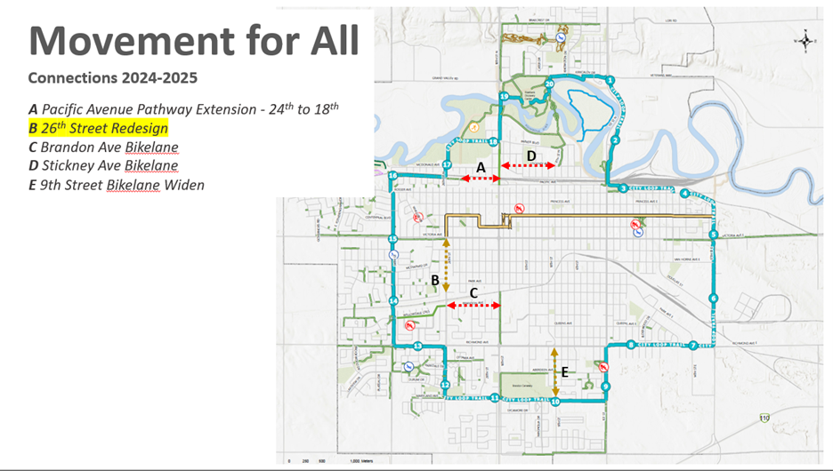
The stretch of 26th Street between Victoria Avenue and Park Avenue is one of those missing AT links. Since this stretch is one of the missing AT links and has been included in the 2024 capital budget for full road reconstruction, the city is proposing to include a bike path as part of the road reconstruction this summer 2024. This presents the opportunity to redesign the street in a manner that allows movement for all.
Movement for all is part of the city-wide vision to provide safe movement options for all residents. This is one of a few projects that will be undertaken in the next few years to create new paths and connect existing paths into a network of bike lanes. The goal is to create an active transportation corridor on 26th Street from Maryland Avenue to Pacific Avenue utilizing bike lanes and multi-use pathways.
What will the end product entail?
The Greenspace Master Plan (2015) identified 26th Street as an Active Transportation (AT) corridor. Typically the design of AT would entail a wide asphalt pathway for pedestrians and cyclists to share (considered a multi-use pathway). Due to the location of the sidewalk and mature trees, a multi-use pathway isn’t a viable option.
In an effort to maximize usage of the roadway for all modes of transportation, the Engineering Department has reviewed traffic and parking volumes. Traffic volumes were found to be similar to other streets within the City that currently consist of one travel lane in each direction. With that information, several concepts were developed that include one travel lane in each direction, parking on both sides of the street, bike lanes and sidewalks on both sides of the street.
Design Options
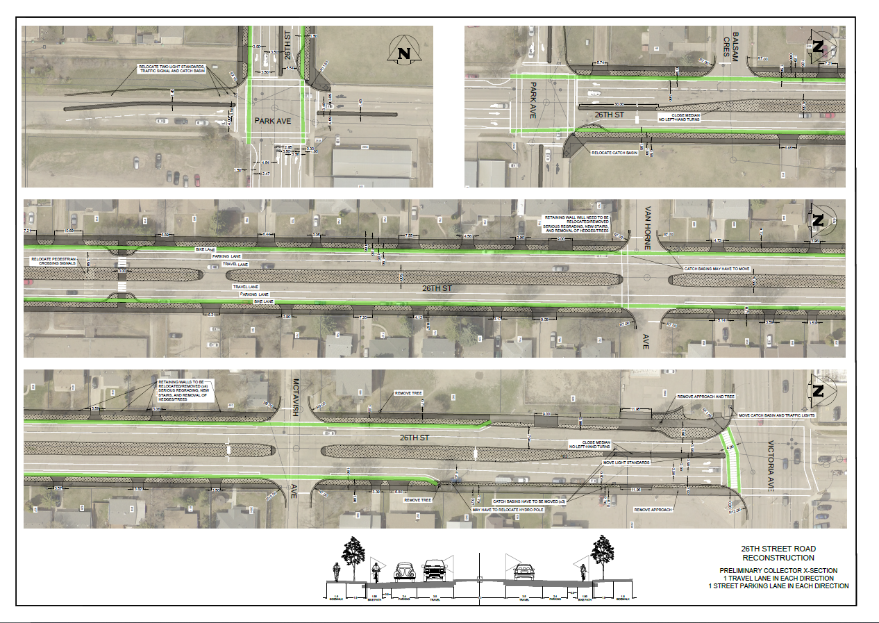
Option 1: Raised Cycle Track:
- Separated from the roadway entirely by a 65mm curb
- More attractive to a wider range of bicyclists at all levels and ages
- Increased vulnerability at intersections
- Requires reconstruction of roadway to allow for implementation
- Requires increased winter maintenance activities
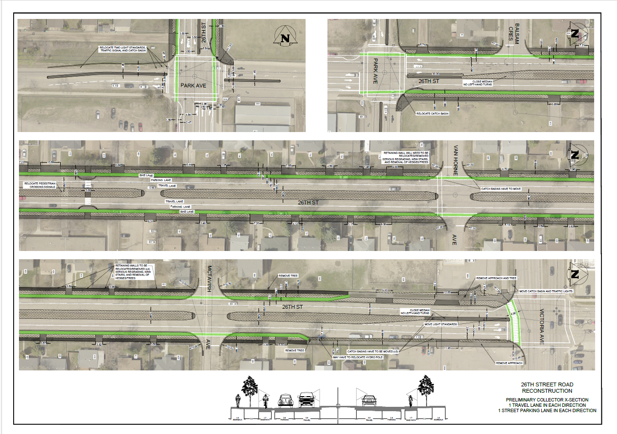
Option 2: Buffered & Protected Bike Lanes:
- Protected by parking lane
- Additional buffer limits conflicts between cyclists & parked vehicles
- Delineated by paint markings and bollards
- Functional concerns during winter months
- Relatively easy to implement throughout 26th street corridor (Richmond Avenue to Pacific Avenue)
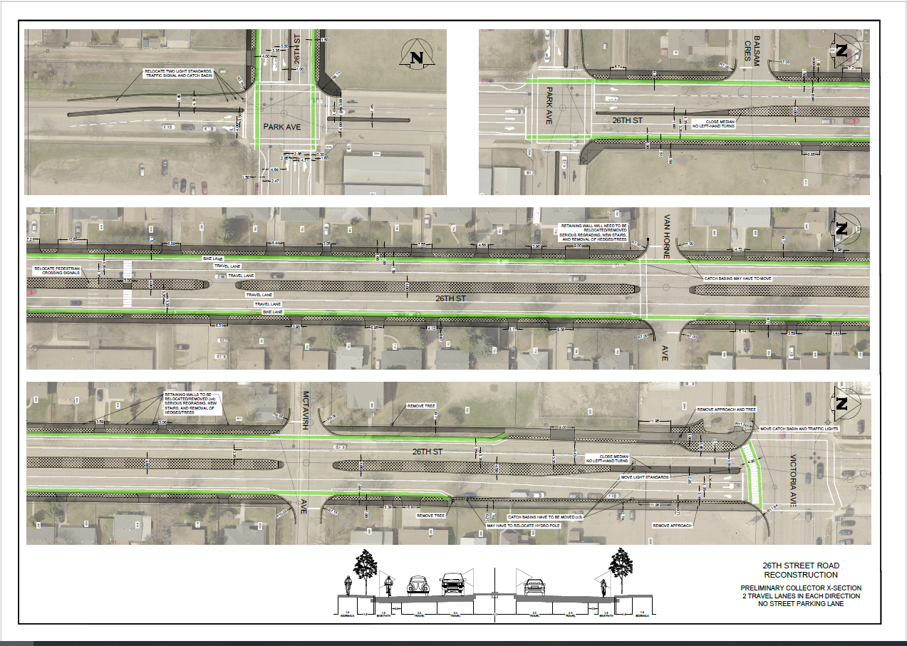
Option 3: Buffered and Protected Bike Lanes - No Parking
- Delineated by paint marking and bollards
- No street parking lane
- 2 travel lanes in each direction
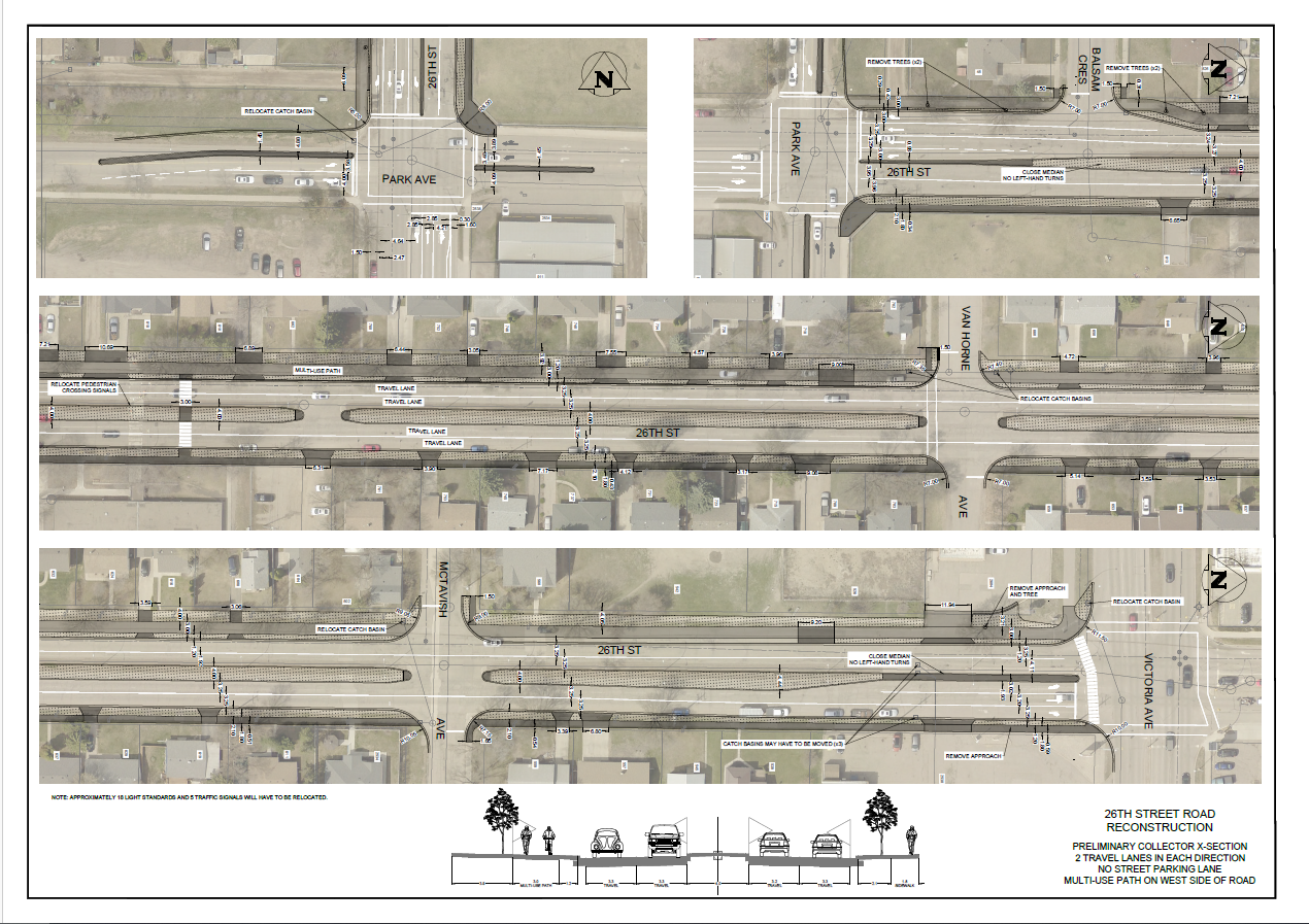
Option 4: Multi-Use Path on West Side of the Street
- Separated from roadway entirely
- Popular and more attractive to a wider range of bicyclists at all levels and ages
- Increased vulnerability at intersections
- Requires reconstruction of roadway or sidewalk to allow for implementation
- More complicated to develop throughout 26th Street corridor (Richmond Ave to Pacific Ave)
- 2 travel lanes in each direction
- No street parking lane
Events
Community Feedback
After reviewing your feedback, there will be a follow-up meeting to go into more detail about the four proposed conceptual designs on April 4th at Vincent Massey (6 p.m.-8 p.m.).
Alternatively if you are unable to attend you can click here to submit your feedback. The deadline to submit your feedback is April 8th, 2024.

